


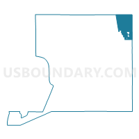
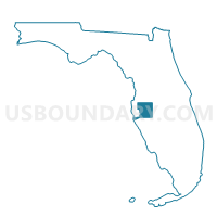
769-Voting District, Hillsborough County, Florida
About
Outline

Summary
| Unique Area Identifier | 553872 |
| Name | 769-Voting District |
| County | Hillsborough County |
| State | Florida |
| Area (square miles) | 42.09 |
| Land Area (square miles) | 41.19 |
| Water Area (square miles) | 0.89 |
| % of Land Area | 97.88 |
| % of Water Area | 2.12 |
| Latitude of the Internal Point | 28.11242970 |
| Longtitude of the Internal Point | -82.08990230 |
Maps

Graphs
Select a template below for downloading or customizing gragh for 769-Voting District, Hillsborough County, Florida


Neighbors
Neighoring Voting District (by Name) Neighboring Voting District on the Map
- 101-Voting District, Polk County, FL
- 106-Voting District, Polk County, FL
- 113-Voting District (Kathleen), Polk County, FL
- 118-Voting District, Polk County, FL
- 122-Voting District, Polk County, FL
- 16A-Voting District, Pasco County, FL
- 16B-Voting District, Pasco County, FL
- 214-Voting District, Polk County, FL
- 755-Voting District, Hillsborough County, FL
- 759A-Voting District, Hillsborough County, FL
- 759B-Voting District, Hillsborough County, FL
- 759C-Voting District, Hillsborough County, FL
- 763-Voting District, Hillsborough County, FL
- 763A-Voting District, Hillsborough County, FL
- 765-Voting District, Hillsborough County, FL
- 766-Voting District, Hillsborough County, FL
Top 10 Neighboring County Subdivision (by Population) Neighboring County Subdivision on the Map
- Lakeland CCD, Polk County, FL (249,148)
- Plant City CCD, Hillsborough County, FL (85,996)
- Zephyrhills CCD, Pasco County, FL (53,335)
Top 10 Neighboring Place (by Population) Neighboring Place on the Map
- Lakeland city, FL (97,422)
- Plant City city, FL (34,721)
- Kathleen CDP, FL (6,332)
- Crystal Springs CDP, FL (1,327)
Top 10 Neighboring Unified School District (by Population) Neighboring Unified School District on the Map
- Hillsborough County School District, FL (1,229,226)
- Polk County School District, FL (602,095)
- Pasco County School District, FL (464,697)
Top 10 Neighboring State Legislative District Lower Chamber (by Population) Neighboring State Legislative District Lower Chamber on the Map
- State House District 61, FL (242,396)
- State House District 64, FL (165,492)
- State House District 62, FL (162,165)
- State House District 63, FL (156,183)
Top 10 Neighboring State Legislative District Upper Chamber (by Population) Neighboring State Legislative District Upper Chamber on the Map
Top 10 Neighboring 111th Congressional District (by Population) Neighboring 111th Congressional District on the Map
- Congressional District 5, FL (929,533)
- Congressional District 12, FL (842,199)
- Congressional District 9, FL (753,549)
Top 10 Neighboring Census Tract (by Population) Neighboring Census Tract on the Map
- Census Tract 121.11, Polk County, FL (5,596)
- Census Tract 120.01, Polk County, FL (5,370)
- Census Tract 121.24, Polk County, FL (5,246)
- Census Tract 101.03, Hillsborough County, FL (4,661)
- Census Tract 130.01, Hillsborough County, FL (3,808)
- Census Tract 101.07, Hillsborough County, FL (3,646)
- Census Tract 330.14, Pasco County, FL (3,270)
- Census Tract 121.25, Polk County, FL (2,876)
- Census Tract 120.04, Polk County, FL (2,369)
- Census Tract 101.08, Hillsborough County, FL (2,144)
Top 10 Neighboring 5-Digit ZIP Code Tabulation Area (by Population) Neighboring 5-Digit ZIP Code Tabulation Area on the Map
- 33810, FL (44,254)
- 33563, FL (25,488)
- 33566, FL (19,522)
- 33565, FL (17,975)
- 33815, FL (14,267)
- 33540, FL (8,752)
- 33849, FL (856)